Fondo Europeo de Desarrollo Regional
Una manera de hacer Europa


Fondo Europeo de Desarrollo Regional
Una manera de hacer Europa
Posted at 25 Feb 2023
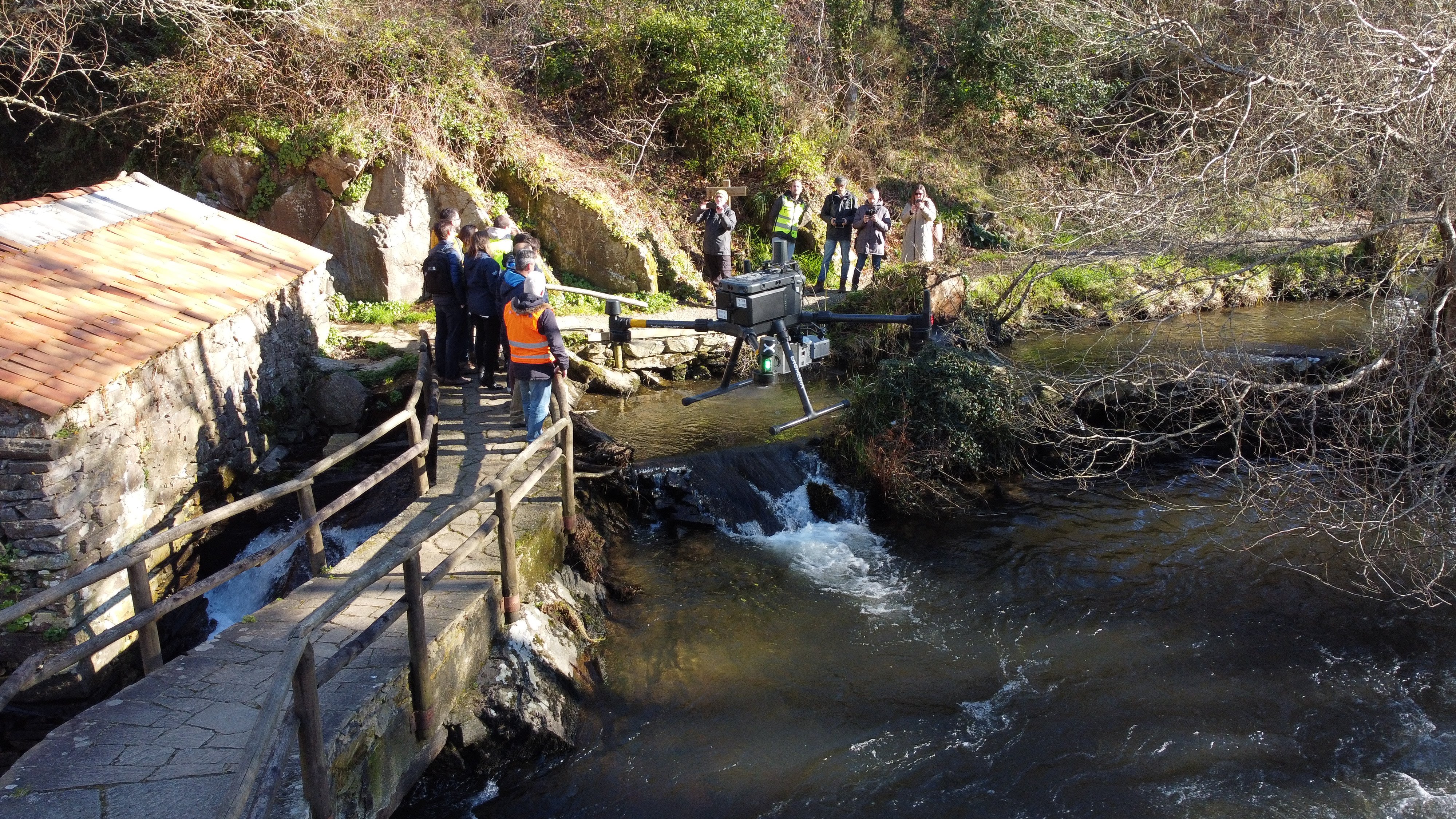
Augas de Galicia technicians are carrying out these days the supervision of a field test with drones in several sections of the rivers of the demarcation owned by the Xunta, focusing these last days on the banks of the river Anllóns, in the region of Bergantiños.
In this case, drones with LIDIAR technology are being used to fly over the area and the data collected will be processed to identify hydromorphological parameters of the river to facilitate the evaluation of the state of the water bodies analyzed, identifying obstacles, riverside vegetation or other types of pressures to which the river could be subjected.
Augas de Galicia periodically carries out the evaluation of the status of the water bodies, which currently involves an important work in field campaigns where technicians have to collect all the necessary data in situ. Thus, the use of drones facilitates the collection of these data in areas that are difficult to access or where a more global vision is needed, which will mean a substantial improvement, both in the quality of the assessments and in the time it takes to carry them out.
This technological solution is part of challenge 1, integrated hydrological information system for advanced management of water resources, of the Innovaugas 4.0 project promoted by the Xunta de Galicia. In this case, the aim is the development, implementation and validation of an integrated technological infrastructure to collect, process and interpret data that allows aggregating and exploiting all the existing information from different sources in order to facilitate appropriate decision-making in the short, medium and long term.
Specifically, the solution that is being carried out under the proposal of the joint venture formed by Viaqua, Gestión Integral de aguas de Galicia, S.A. and the Fundación Instituto Tecnológico de Galicia, will allow the integrated management of a huge amount of data from very diverse sources such as historical data and predictions of rainfall, temperatures, results of water quality analysis and many other measurements made by the sensors arranged in the system of Augas de Galicia.
This innovative solution will guarantee the future integration of new sources of information, as well as the particular configuration of the Galicia-Costa hydrographic demarcation and the need to record news variables that allow to know the impacts produced by climate change in the management of water resources.
The technology, which does not exist in the current purchase, will be the best answer to store, exchange and manage current and future data, including data exchange with citizens; to analyze, process and treat the available data in an advanced way, applying statistical and artificial intelligence techniques to model future scenarios; and to develop and implement applications that, based on all this available data, and with artificial intelligence, will make it possible to provide answers to specific problems.
Innovaugas 4.0 is a project promoted by the Xunta, through Augas de Galicia, which seeks to achieve new solutions for advanced integrated water management, optimize water resources and provide a long-term response to the demands of different water uses, in balance with the natural environment and river ecosystems, respecting the achievement of the environmental objectives established for water bodies and addressing the new scenarios determined by climate change.
The Innovaugas 4.0 project has a budget of €7 million and is 80% co-financed by the European Regional Development Fund (ERDF) through Spain's Pluri-regional Operational Program (POPE) 2014-2020.
Innovaugas 4.0 was selected by the Ministry of Science and Innovation in 2020 and has a grant of €4.2 million from European funds, and is also co-financed by the Galician Innovation Agency, with €700,000, and by Augas de Galicia, with €2.1 million.